Air Travel in the Greater McMurdo Area
We have three airfields here in McMurdo. They include the Annual Ice Runway, Williams Field Skiway, and Pegasus White Ice Runway. Here is a map of the south end of Ross Island.

There are five points of interest that I will point out. And don’t forget to click on the map to get a larger view of it. The red dot is McMurdo station and the purple dot is Scott Base (the New Zealand base) which is over the hill from MacTown. The three lines show the three airfields. The yellow line is the Ice Runway, the green line is Willy Field, and the blue line is Pegasus. Also shown is a thin purple line goes west across McMurdo Sound, this is the edge of the Ross Ice Shelf. All of the water that you see on this map is frozen sea ice currently. The edge of the open ocean water is near Cape Royds at this time. The Ross Ice Shelf is still over water, however it is a glacier and it is several hundred feet thick. As compared to the sea ice which is between 6 and 28 feet thick. So, as you can see the Ice Runway is on sea ice and the other two fields are on the ice shelf.
So why do we have three airfields??? Let me give you a description of each airfield first.
The Annual Ice Runway is built during WINFLY and is used from October to December each year. It is built right on the sea ice surface and it is a groomed ice surface. It is 10,000 feet long and 1000 feet wide. The runway is only a mile from town and so it is very convenient to get to for maintenance crews, cargo crews, and for passengers. The downside of the runway is that it is on top of the ocean and ice melts when it gets warm. The ice is actually blue in color and so it actually melts quicker that ice with a coating of white snow on top of it. So the 24 hours a day of sunlight is starting to take a toll on the surface. Survey crews are checking the condition of the ice constantly. They are checking the depth of the ice, the temperature of the ice, and the consistency of the ice. To give you some perspective on how strong the sea ice is, a loaded C-17 plane that lands at McMurdo weighs 485,000 pounds. All of the planes that come here can land on this surface both wheeled and ski equipped. This runway is scheduled to close this Friday. If you want to land on the Ice Runway you better get your tickets ASAP.
The next airfield is Willy Field Skiway. This field is named after Navy Seabee Richard Thomas Williams who drown after his tractor broke through the sea ice in 1956. Willy Field is a snow skiway that is built on 25 feet of compacted snow which sits on 260 feet of ice. It is used by the ski equipped C-130’s from New York and the Twin Otters which also have skis. It is seven miles from Willy to MacTown most of which is on a snow road across the ice shelf. This is the only field with a crosswind runway for use in different wind directions.
And the last airfield is Pegasus White Ice Runway. Pegasus is named for a plane that crashed on the ice shelf. The plane is still on the ice shelf and there are tours out to the crash site from town from time to time. Pegasus is used for wheeled flight operations during WINFLY and after the Ice Runway is closed. It is 18 miles from town and it is connected to Willy Field with a snow road. This runway is an evolution of ice runway construction techniques. It was first built about 10 years ago and it was built similar to the Ice Runway. All of the snow was removed from the strip and the remaining blue ice was groomed for a runway. The problem with this is the fact that blue ice absorbs the heat of the sun faster than the white snow. This isn’t going to melt out the runway since the glacier is 110 feet thick at this point, but it would case melt pools on the runway and maintenance issues. At some point in time they decided to use the large snowblasts to blow a covering of snow back onto the runway when it was not in use to keep the sun from melting the ice. And when the next flight was planned to come in they would blow the snow back off. Well then this evolved into keeping the snow on the ice and compacting it with several 185,000 pound compactors. This made a two inch thick white ice surface for the runway. Here we have the best of worlds, a surface strong enough to land a loaded C-17 on it and a white surface to keep the maintenance to a minimum.
So that is a little bit about the airfields here in town. As I said the Ice Runway will close on Friday. And the entire Ice Town will be moved to either Willy or Pegasus and they will both be up and running on Monday. A very large task for one weekend. One other interesting change for this year was that all three airfields had their navigational systems up and running at the same time this October so that all three could get FAA certified at one time instead of as the airfields open. This was a pretty major feat for all involved.
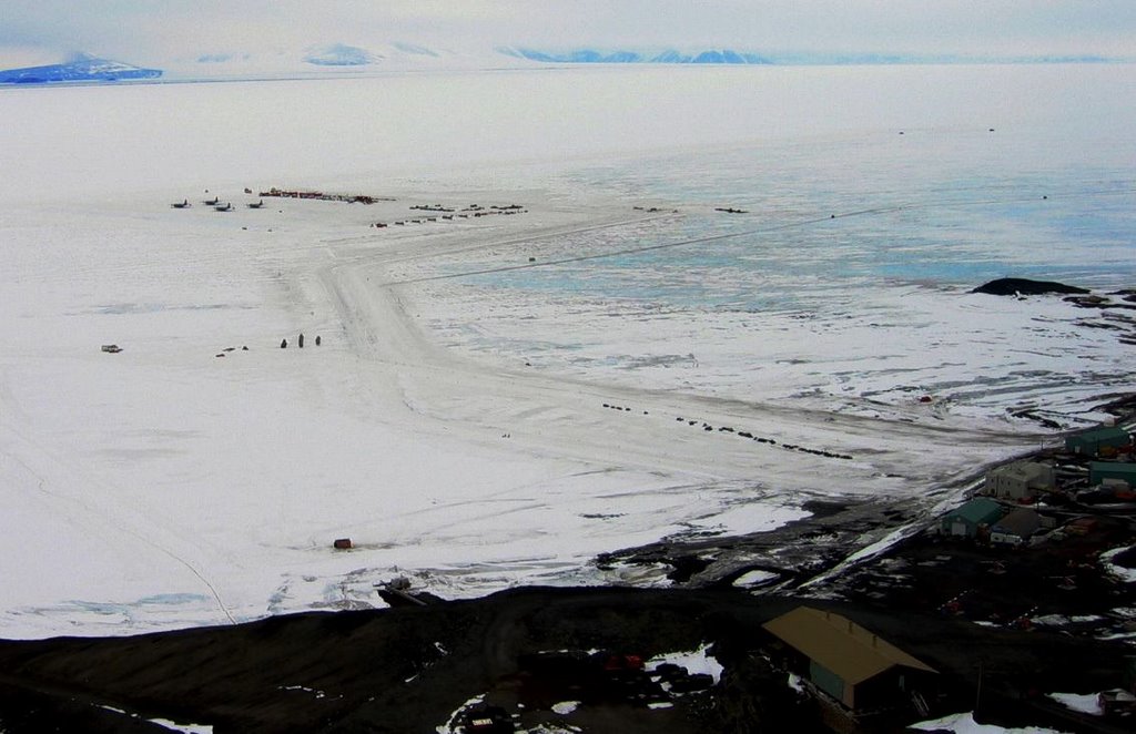
Here is a photo take from the top of Ob Hill this past Sunday. Ob Hill is the 750’ peak right between McMurdo and Scott Base. I will try to give you an idea of the layout of the Ice Runway.

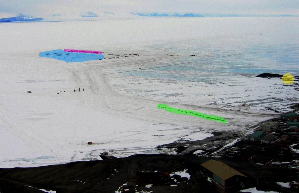
You can easily see the edge of McMurdo on the right and the mountains across the sound in the distance. And you can see 4 C-130’s sitting on the ramp. The next photo gives you some of the layout of Ice Town and the surroundings.

The blue area is the taxiway, cargo loading area, fueling pits, and plane parking area. The purple area is Ice Town. There is all of the building required for the NYANG to maintain their fleet as well as cargo housing, generators, flight tower, fire house and other buildings. The green area in the foreground is snowmobile parking. There is up to 100 snowmobiles parked there at one time. And off to the right in yellow is the Discovery Hut that Scott built in 1901.

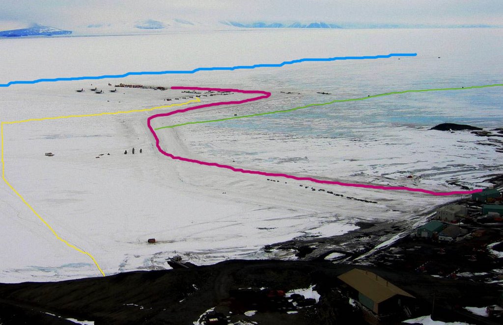
This photo is a layout of some other important areas of the Ice Runway. The pink line is the roadway from the ice/land transition to Ice Town. The area close to the land near the snowmobiles is exciting this time of year. The snow is soft and it is easy to get stuck and you cross over several open cracks in the ice along the shore. The green line is the road north to Cape Evans. If you look closely you can see two dots on the road, they are Pisten Bullies headed out to explode hydraulic lines for us to fix. The blue line is the runway. The planes go from right to left as they land and as they takeoff. The two little dots at the right end are a 220kW generator and the navigational aid building that the generator powers. And the yellow line is the fuel line for the airfield. They lay a 6 inch fuel hose out to the fuel pits to re-supply the aircraft. This line is impressive at a mile long, but Gary has laid more LDH than that before. They also lay a fuel line to Willy Field. How about a 6 mile LDH run, that is very impressive. The fuel for Pegasus is tankered out from Willy Field.
R.J.
PS have fun in CA!

There are five points of interest that I will point out. And don’t forget to click on the map to get a larger view of it. The red dot is McMurdo station and the purple dot is Scott Base (the New Zealand base) which is over the hill from MacTown. The three lines show the three airfields. The yellow line is the Ice Runway, the green line is Willy Field, and the blue line is Pegasus. Also shown is a thin purple line goes west across McMurdo Sound, this is the edge of the Ross Ice Shelf. All of the water that you see on this map is frozen sea ice currently. The edge of the open ocean water is near Cape Royds at this time. The Ross Ice Shelf is still over water, however it is a glacier and it is several hundred feet thick. As compared to the sea ice which is between 6 and 28 feet thick. So, as you can see the Ice Runway is on sea ice and the other two fields are on the ice shelf.
So why do we have three airfields??? Let me give you a description of each airfield first.
The Annual Ice Runway is built during WINFLY and is used from October to December each year. It is built right on the sea ice surface and it is a groomed ice surface. It is 10,000 feet long and 1000 feet wide. The runway is only a mile from town and so it is very convenient to get to for maintenance crews, cargo crews, and for passengers. The downside of the runway is that it is on top of the ocean and ice melts when it gets warm. The ice is actually blue in color and so it actually melts quicker that ice with a coating of white snow on top of it. So the 24 hours a day of sunlight is starting to take a toll on the surface. Survey crews are checking the condition of the ice constantly. They are checking the depth of the ice, the temperature of the ice, and the consistency of the ice. To give you some perspective on how strong the sea ice is, a loaded C-17 plane that lands at McMurdo weighs 485,000 pounds. All of the planes that come here can land on this surface both wheeled and ski equipped. This runway is scheduled to close this Friday. If you want to land on the Ice Runway you better get your tickets ASAP.
The next airfield is Willy Field Skiway. This field is named after Navy Seabee Richard Thomas Williams who drown after his tractor broke through the sea ice in 1956. Willy Field is a snow skiway that is built on 25 feet of compacted snow which sits on 260 feet of ice. It is used by the ski equipped C-130’s from New York and the Twin Otters which also have skis. It is seven miles from Willy to MacTown most of which is on a snow road across the ice shelf. This is the only field with a crosswind runway for use in different wind directions.
And the last airfield is Pegasus White Ice Runway. Pegasus is named for a plane that crashed on the ice shelf. The plane is still on the ice shelf and there are tours out to the crash site from town from time to time. Pegasus is used for wheeled flight operations during WINFLY and after the Ice Runway is closed. It is 18 miles from town and it is connected to Willy Field with a snow road. This runway is an evolution of ice runway construction techniques. It was first built about 10 years ago and it was built similar to the Ice Runway. All of the snow was removed from the strip and the remaining blue ice was groomed for a runway. The problem with this is the fact that blue ice absorbs the heat of the sun faster than the white snow. This isn’t going to melt out the runway since the glacier is 110 feet thick at this point, but it would case melt pools on the runway and maintenance issues. At some point in time they decided to use the large snowblasts to blow a covering of snow back onto the runway when it was not in use to keep the sun from melting the ice. And when the next flight was planned to come in they would blow the snow back off. Well then this evolved into keeping the snow on the ice and compacting it with several 185,000 pound compactors. This made a two inch thick white ice surface for the runway. Here we have the best of worlds, a surface strong enough to land a loaded C-17 on it and a white surface to keep the maintenance to a minimum.
So that is a little bit about the airfields here in town. As I said the Ice Runway will close on Friday. And the entire Ice Town will be moved to either Willy or Pegasus and they will both be up and running on Monday. A very large task for one weekend. One other interesting change for this year was that all three airfields had their navigational systems up and running at the same time this October so that all three could get FAA certified at one time instead of as the airfields open. This was a pretty major feat for all involved.
Here is a photo take from the top of Ob Hill this past Sunday. Ob Hill is the 750’ peak right between McMurdo and Scott Base. I will try to give you an idea of the layout of the Ice Runway.
You can easily see the edge of McMurdo on the right and the mountains across the sound in the distance. And you can see 4 C-130’s sitting on the ramp. The next photo gives you some of the layout of Ice Town and the surroundings.
The blue area is the taxiway, cargo loading area, fueling pits, and plane parking area. The purple area is Ice Town. There is all of the building required for the NYANG to maintain their fleet as well as cargo housing, generators, flight tower, fire house and other buildings. The green area in the foreground is snowmobile parking. There is up to 100 snowmobiles parked there at one time. And off to the right in yellow is the Discovery Hut that Scott built in 1901.
This photo is a layout of some other important areas of the Ice Runway. The pink line is the roadway from the ice/land transition to Ice Town. The area close to the land near the snowmobiles is exciting this time of year. The snow is soft and it is easy to get stuck and you cross over several open cracks in the ice along the shore. The green line is the road north to Cape Evans. If you look closely you can see two dots on the road, they are Pisten Bullies headed out to explode hydraulic lines for us to fix. The blue line is the runway. The planes go from right to left as they land and as they takeoff. The two little dots at the right end are a 220kW generator and the navigational aid building that the generator powers. And the yellow line is the fuel line for the airfield. They lay a 6 inch fuel hose out to the fuel pits to re-supply the aircraft. This line is impressive at a mile long, but Gary has laid more LDH than that before. They also lay a fuel line to Willy Field. How about a 6 mile LDH run, that is very impressive. The fuel for Pegasus is tankered out from Willy Field.
R.J.
PS have fun in CA!
posted by R.J. at 3:45 AM
![]()
![]()

1 Comments:
In honor of Paula and your penguin sightings,we went to the movies and saw Happy Feet last night. Jamie & Missy
Post a Comment
<< Home